The Project is being evaluated for its prospective subsurface salt and potential future underground energy-storage applications.
Updated geological and geophysical interpretations provide a technical framework for selecting future drilling locations and advancing project evaluation.
The population of Newfoundland and Labrador is 531,948
Situated within a region containing established communities and road, electrical and service infrastructure.
Figure 1: Location Map of the Robinsons River Salt Property, Newfoundland
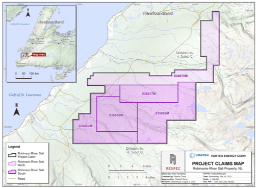
Figure 2: Robinsons River Salt Property Claims and Licenses, Newfoundland
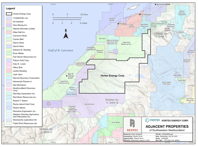
Adjacent Properties
Atlas Salt (TSXV: SALT) Great Atlantic Salt Deposit is located 15 km north of the Property. The salt deposit contains an Inferred resource of 908 million tonnes grading 96.9% NaCl using a nominal bulk density of 2.16 g/cm³ (nominal de-icing market standard).*
Thick high-grade homogenous deposit
Scalable to mining 2.5 Mtp
Triple Point Resources (Private) Fischell Salt Dome is located to the North of the property and can potentially store approximately 180,000 tonnes of hydrogen.
*This resource estimate was independently prepared by APEX Geoscience Ltd. for Atlas Salt in accordance with NI 43-101. The Company has not had a qualified person verify this information, and this information is not necessarily indicative of the mineralization on the Robinsons River Salt Property.
Figure 3: Map of Mineral Occurrences and Active Adjacent Properties
Property Geology
The Project lies within the Carboniferous Bay St. George Subbasin, part of the broader Maritimes Basin, which hosts evaporite-bearing rocks of the Codroy Group.
The updated Drill hole VTX-West-24-02 intersected approximately 278 m of gross salt-bearing stratigraphy within the western target area; the interval includes salt and non-salt material.
Reprocessed gravity data identify a large, untested eastern target that may contain additional, potentially cleaner salt; this remains an unconfirmed exploration hypothesis.
mining processing; and
The potential for cavern placement and hydrogen storage refining requires understanding the host rock formation’s quality, thickness and deformation properties. By advancing exploration efforts to include drilling the identified potential salt structure, the capacity for hydrogen storage can be better defined.
Please refer to the website disclaimer for additional information regarding the exploration information presented on this website.
Geology Map of the Robinsons River Salt Property, Newfoundland
Drilling Confirms Western Salt-Bearing System
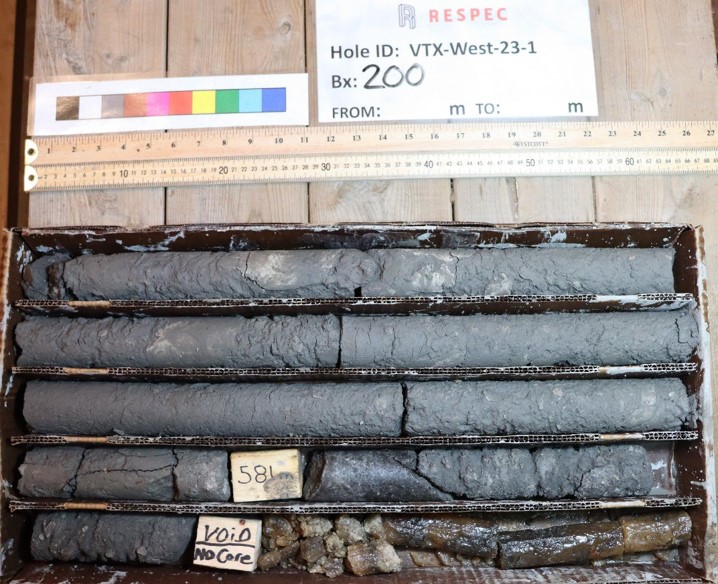
Drill hole VTX-West-23-1 was drilled to 608 metres, with the first salt rock reported at approximately 581.5 metres depth.1
Logging identified predominantly halite-bearing salt with intermixed mudstone and localized potash minerals, including carnallite and possible sylvite.2
Selected core is undergoing mineralogical, petrophysical and geomechanical investigation to assess salt composition, impurities, sealing properties and mechanical behaviour.4
Additional core characterization and drilling are required before cavern design or storage capacity can be evaluated.3
Sources: RESPEC Consulting Inc., Independent Technical Report on the Robinsons River Salt Property, July 31, 2023.1
Durling, P. et al., Seismic Expression of the Codroy Group in the St. George’s Bay Lowlands and Offshore Area, Western Newfoundland, Geological Survey of Canada, 2023.2
Lonquist Field Service (Canada), ULC, Robinsons River Salt Project Technical Study, 2026; summarized in Vortex Energy Corp., Vortex Energy Receives Final Results on Technical Study for Robinsons River Salt Project, 2026.3
Vortex Energy Corp., Update on Technical Research and Exploration Activities at the Robinsons River Salt Project, July 17, 2025.4
Evolution of the Geological Model
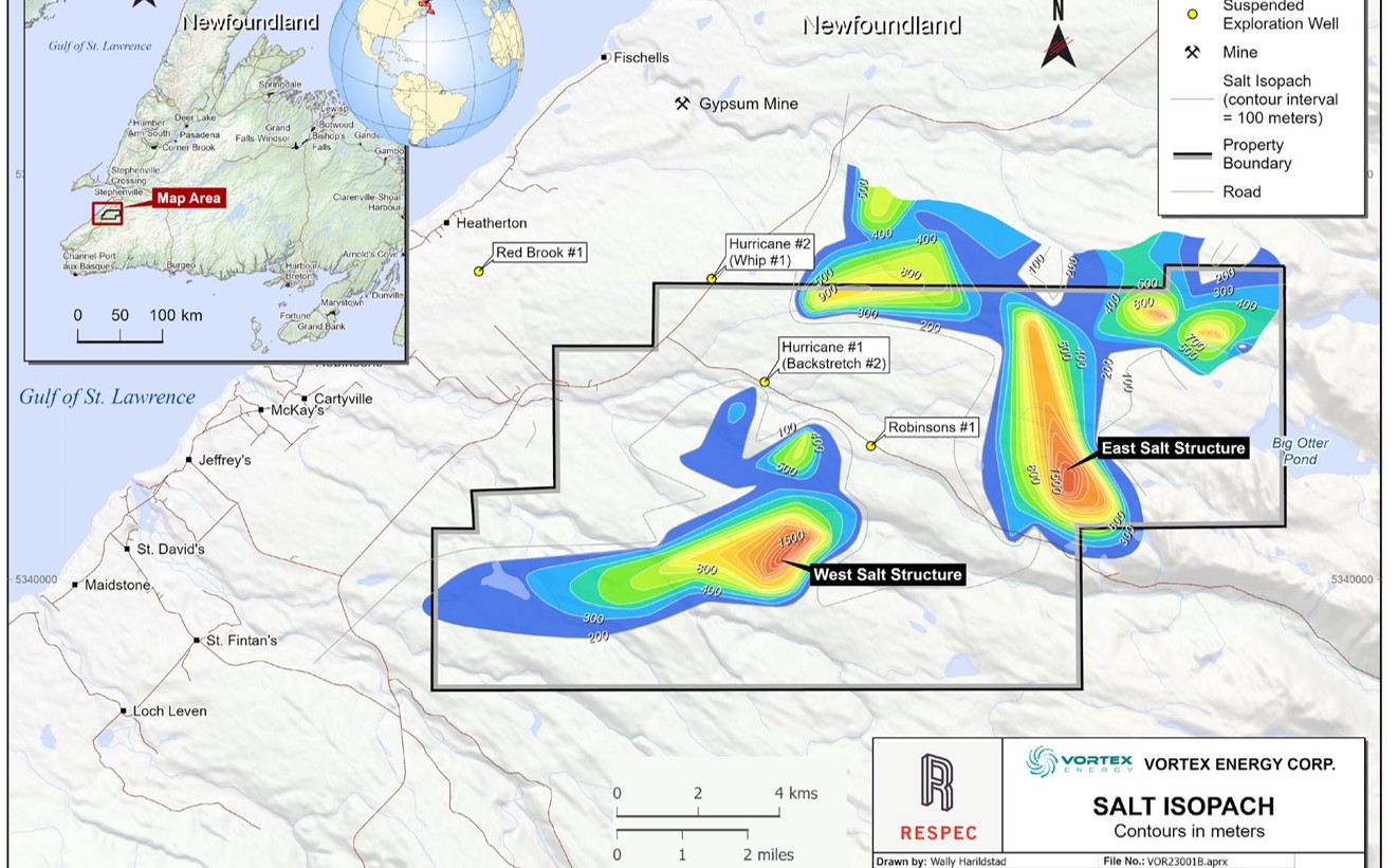
2023 Conceptual Model: Historical seismic and gravity data were interpreted as two large potential salt structures, forming the basis of a preliminary cavern-layout and storage-capacity assessment.1
2023-24 Drilling: Vortex drilling confirmed salt-bearing stratigraphy in the western target area but demonstrated that salt distribution is more complex and interbedded than represented in the original model.2,3
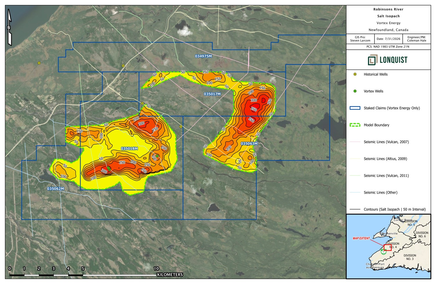
2026 Reinterpretation: Lonquist’s integration of drilling, seismic and reprocessed gravity data supports a substantial western salt-bearing body and the approximately 350-metre “Cloverleaf” step-out opportunity.4
Additional Exploration Target: Reprocessed gravity also identifies a large, untested eastern target that may contain additional salt but requires geophysical refinement and drilling confirmation.4
Sources: RESPEC Consulting Inc., Independent Technical Report on the Robinsons River Salt Property, July 31, 2023.1
Vortex Energy Corp., Vortex Energy Intersects Salt on the Western Salt Structure, December 14, 2023..2
Vortex Energy Corp., Vortex Energy Intersects Salt on the Western Salt Structure, December 14, 2023..3
Lonquist Field Service (Canada), ULC, Robinsons River Salt Project Technical Study, 2026.4
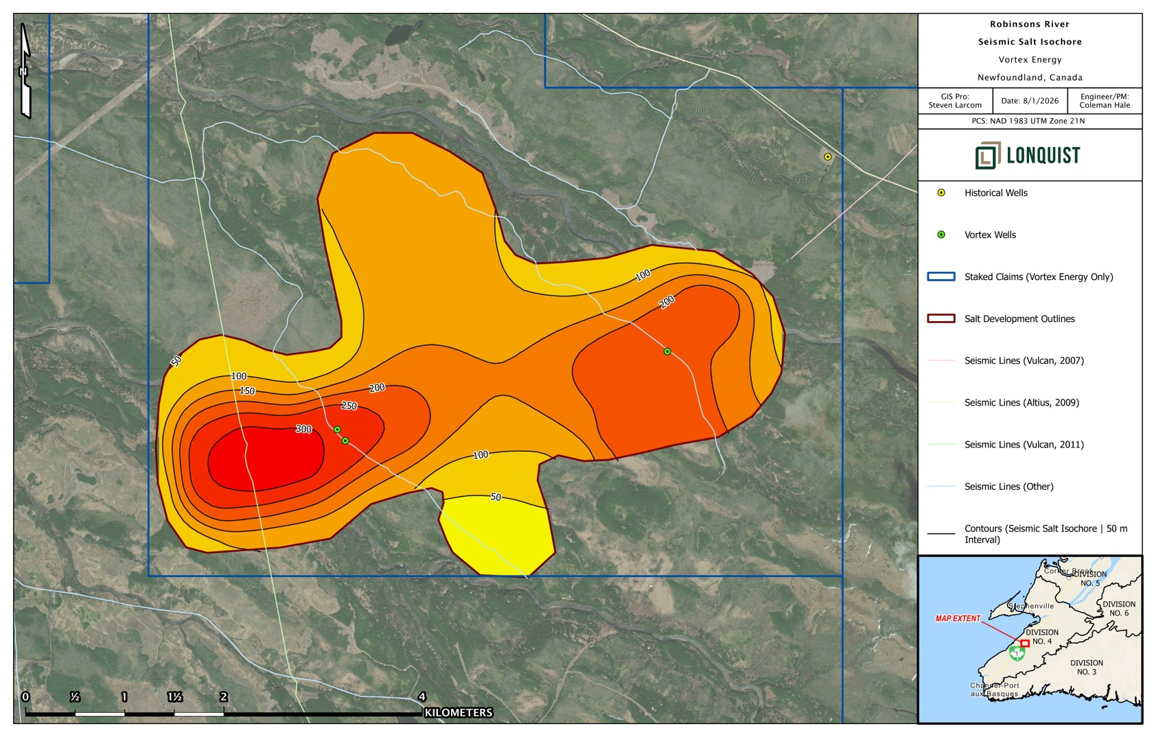
Updated seismic-derived interpretation of prospective salt thickness developed during the 2026 technical review. Values are interpretive and constrained by available seismic coverage and drilling control
Depth to Salt and Exploration Implications
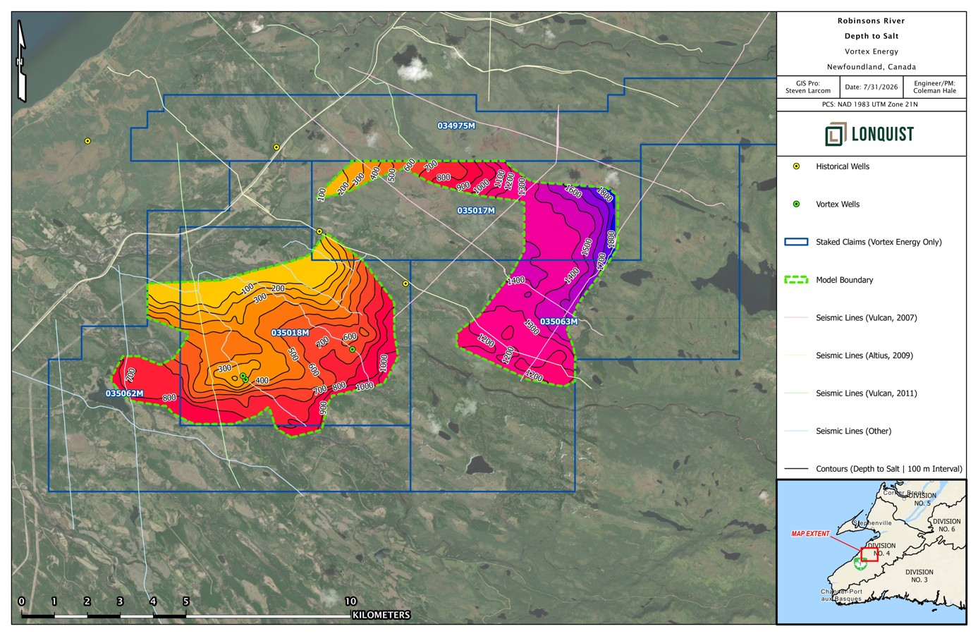
Drilling confirms that the depth and composition of salt-bearing stratigraphy vary materially across the western target area.
VTX-West-23-1 first encountered salt at approximately 581.5 metres, while VTX-West-24-2 encountered visible salt beginning at approximately 327 metres.
The large eastern target remains untested, with its prospective top interpreted at approximately 1,100-1,300 metres below surface.
Salt depth is an important input to future drilling, well design, operating-pressure limits, cavern geometry and project economics. Additional drilling and geotechnical data are required.
Interpreted depth to prospective salt-bearing stratigraphy. Depths outside drilling control are interpretive and require confirmation
Integrated Geophysical Interpretation
Airborne gravity-gradiometry and magnetic surveys provided property-scale density and structural information for the original 2023 subsurface model.1
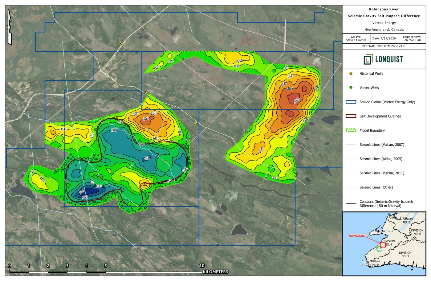
Gravity lows may be consistent with lower-density evaporites, but can also reflect non-salt lithologies, geological structure and processing assumptions; they are not direct evidence of salt.1,2
Lonquist reprocessed and recalibrated the gravity interpretation using available seismic and drilling control, including wells that did not intersect material salt.1,2
Additional drilling, density measurements and geophysical refinement are required to confirm salt distribution and improve the subsurface model.2
Sources: RESPEC Consulting Inc., Independent Technical Report on the Robinsons River Salt Property, July 31, 2023.1
Lonquist Field Service (Canada), ULC, Robinsons River Salt Project Technical Study, 2026.2
Difference between seismic- and gravity-derived salt-thickness interpretations. The datasets are related but do not provide identical representations of salt distribution
Integrated Geophysical Interpretation
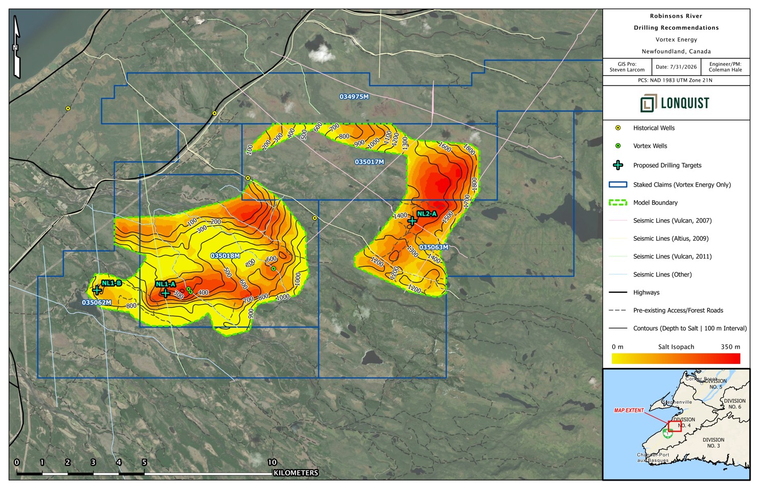
Eastern Target: Proposed target NL2-A would test the depth, thickness and salt quality of the large, untested eastern gravity target. Potentially cleaner salt is an exploration hypothesis that remains unconfirmed by drilling.
Western Targets: Proposed targets NL1-A and NL1-B would provide additional control within the established western system and western gravity anomaly, improving confidence in the geological and gravity models.
Cloverleaf Step-Out: Follow-up drilling may test the locally thickened Cloverleaf area, where seismic interpretation indicates approximately 350 m of prospective salt-bearing stratigraphy
Pre-Drilling Work: Recommended work includes detailed VTX-West-24-02 core characterization, representative density measurements, salt-percentage determination and assessment of freshwater availability and brine-disposal capacity.
Positive results would support detailed well design, model refinement, geomechanical testing and subsequent cavern-suitability and storage-capacity assessment.
Conceptual drilling targets identified through the 2026 integrated technical review. Locations are approximate planning concepts and are not approved drill sites
Pathway to Drilling
Step 1, Step 2, and Step 3 complete
Drilling permit was submitted on August 24, 2023
Drilling began November 20, 2023
Drilling Objective
Drill three modern full-length core wells
Conducting a full suit of geophysical wireline surveys in the core wells along with a comprehensive sampling program
Step 1
Gravity Survey &
2D Seismic
Complete
Step 2
3D Modelling &
Drill Targeting
Complete
Step 3
Permitting &
Contractor Mobilization
Complete
Step 4
Permitting &
Contractor Mobilization
Ongoing
Phase II: Drilling
Scope of Work Developed & Managed by RESPEC
Robinsons River South Property
Pre-Drilling & Well Design
Permitting & Procurement of Services
Active Drilling Contractor Management
Geological Reporting
Well Location and Geology
Well Objectives
Preliminary Design Considerations
Design Documentation
Preliminary Drilling Plan
Preliminary Rig Selection
Well Permitting & Regulatory Requirements
Exploration Approval Application
Procurement of Drilling Services
Planning Logistics
Project Management
Drilling Operations
Postfield Program Memoranda
Integrated Field-to-Office Server
Assessment Reports
Technical Program Reports
Evolution of the Geological Model
2023 Conceptual Model: Historical seismic and gravity data were interpreted as two large potential salt structures, forming the basis of a preliminary cavern-layout and storage-capacity assessment.1
2023-24 Drilling: Vortex drilling confirmed salt-bearing stratigraphy in the western target area but demonstrated that salt distribution is more complex and interbedded than represented in the original model.2,3
2026 Reinterpretation: Lonquist’s integration of drilling, seismic and reprocessed gravity data supports a substantial western salt-bearing body and the approximately 350-metre “Cloverleaf” step-out opportunity.4
Additional Exploration Target: Reprocessed gravity also identifies a large, untested eastern target that may contain additional salt but requires geophysical refinement and drilling confirmation.4
Sources: RESPEC Consulting Inc., Independent Technical Report on the Robinsons River Salt Property, July 31, 2023.1
Vortex Energy Corp., Vortex Energy Intersects Salt on the Western Salt Structure, December 14, 2023..2
Vortex Energy Corp., Vortex Energy Intersects Salt on the Western Salt Structure, December 14, 2023..3
Lonquist Field Service (Canada), ULC, Robinsons River Salt Project Technical Study, 2026.4
For additional information regarding the Robinsons River Salt Property, we encourage you to review the full technical report on the Robinsons River Salt Property. Click here to review the full report.”