100% Crown subsurface mineral rights within the Elk Point Group.
Located in Townships 65–66, Ranges 26–27, west of the Third Meridian.
Eight-year permit term commencing July 14, 2026.
Highway 919 and regional resource roads provide access into the project area.
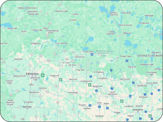
The town of Meadow Lake is the principal regional logistics and service centre.
The Meadow Lake project area
Nearby Evidence
Four nearby historical wells provide regional control around the project area.
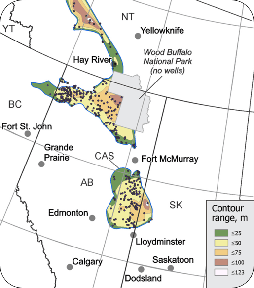
Reported halite-dominated intervals range from approximately 75 m to 123 m, and demonstrate that substantial Elk Point salt thicknesses occur in the region.
Historical drilling was completed primarily for oil-and-gas purposes and did not include the modern testing required to evaluate cavern development.
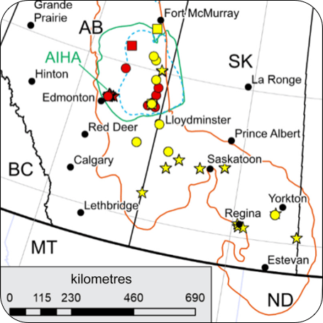
Multiple operating or developing salt-cavern projects in eastern Alberta provide relevant regional analogues for the geological concept.
Property Geology
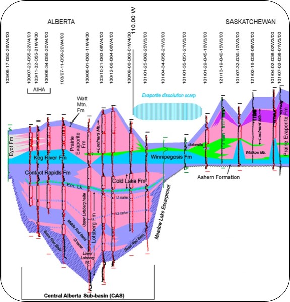
The project targets Devonian Elk Point Group evaporites interpreted to include Cold Lake Formation-correlative halite.
Salt distribution is controlled by the regional dissolution margin to the east and wedge-out against the pre-Devonian Meadow Lake Escarpment.
The acquired permit occupies part of the resulting exploration corridor between these two regional geological boundaries.
Nearby historical wells indicate that locally thick halite is present, but salt thickness, continuity and quality beneath SMP273 have not yet been confirmed.
The primary objective is to identify a continuous clean-salt interval at a suitable depth and sufficient distance from the interpreted dissolution and depositional margins.
Please refer to the website disclaimer for additional information regarding the exploration information presented on this website.
Estimated Thickness Of The Cold Lake Formation Halite
Development Concept
Cold Lake Formation salt in Alberta demonstrates that Elk Point halite can support solution-mined storage caverns, and the same regional stratigraphic interval is interpreted to extend into the project area.
Continuity, purity, interbed frequency, caprock integrity, depth, geomechanical behaviour and hydrogeology still need to be established.
Water supply, brine management, surface access and regulatory constraints must also be screened before significant drilling or engineering expenditures.
Proposed work programs are designed to test these conditions in stages and avoid advancing a geologically attractive target that lacks a practical development pathway.
Sonar Profile Of An Existing Salt Cavern In The Salt Formation On Alberta-side
Depth to Salt and Exploration Implications
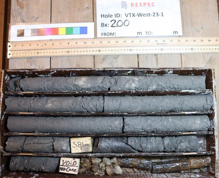
Drilling confirms that the depth and composition of salt-bearing stratigraphy vary materially across the western target area.
VTX-West-23-1 first encountered salt at approximately 581.5 metres, while VTX-West-24-2 encountered visible salt beginning at approximately 327 metres.
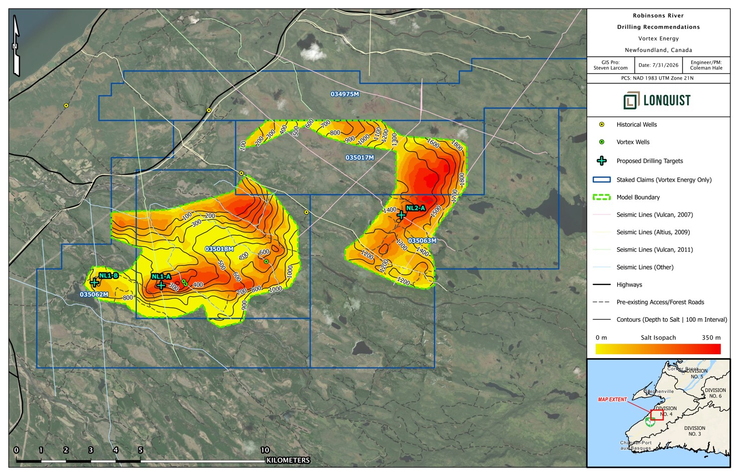
The large eastern target remains untested, with its prospective top interpreted at approximately 1,100-1,300 metres below surface.
Salt depth is an important input to future drilling, well design, operating-pressure limits, cavern geometry and project economics. Additional drilling and geotechnical data are required.
Connecting Historic Drill Hole Data Across AB-SK; Pink = Halite
Integrated Geophysical Interpretation
Eastern Target: Proposed target NL2-A would test the depth, thickness and salt quality of the large, untested eastern gravity target. Potentially cleaner salt is an exploration hypothesis that remains unconfirmed by drilling.
Western Targets: Proposed targets NL1-A and NL1-B would provide additional control within the established western system and western gravity anomaly, improving confidence in the geological and gravity models.
Cloverleaf Step-Out: Follow-up drilling may test the locally thickened Cloverleaf area, where seismic interpretation indicates approximately 350 m of prospective salt-bearing stratigraphy
Pre-Drilling Work: Recommended work includes detailed VTX-West-24-02 core characterization, representative density measurements, salt-percentage determination and assessment of freshwater availability and brine-disposal capacity.
Positive results would support detailed well design, model refinement, geomechanical testing and subsequent cavern-suitability and storage-capacity assessment.
Conceptual drilling targets identified through the 2026 integrated technical review. Locations are approximate planning concepts and are not approved drill sites
Pathway to Drilling
Step 1, Step 2, and Step 3 complete
Drilling permit was submitted on August 24, 2023
Drilling began November 20, 2023
Drilling Objective
Drill three modern full-length core wells
Conducting a full suit of geophysical wireline surveys in the core wells along with a comprehensive sampling program
Step 1
Gravity Survey &
2D Seismic
Complete
Step 2
3D Modelling &
Drill Targeting
Complete
Step 3
Permitting &
Contractor Mobilization
Complete
Step 4
Permitting &
Contractor Mobilization
Ongoing
Phase II: Drilling
Scope of Work Developed & Managed by RESPEC
Robinsons River South Property
Pre-Drilling & Well Design
Permitting & Procurement of Services
Active Drilling Contractor Management
Geological Reporting
Well Location and Geology
Well Objectives
Preliminary Design Considerations
Design Documentation
Preliminary Drilling Plan
Preliminary Rig Selection
Well Permitting & Regulatory Requirements
Exploration Approval Application
Procurement of Drilling Services
Planning Logistics
Project Management
Drilling Operations
Postfield Program Memoranda
Integrated Field-to-Office Server
Assessment Reports
Technical Program Reports
Evolution of the Geological Model
2023 Conceptual Model: Historical seismic and gravity data were interpreted as two large potential salt structures, forming the basis of a preliminary cavern-layout and storage-capacity assessment.1
2023-24 Drilling: Vortex drilling confirmed salt-bearing stratigraphy in the western target area but demonstrated that salt distribution is more complex and interbedded than represented in the original model.2,3
2026 Reinterpretation: Lonquist’s integration of drilling, seismic and reprocessed gravity data supports a substantial western salt-bearing body and the approximately 350-metre “Cloverleaf” step-out opportunity.4
Additional Exploration Target: Reprocessed gravity also identifies a large, untested eastern target that may contain additional salt but requires geophysical refinement and drilling confirmation.4
Sources: RESPEC Consulting Inc., Independent Technical Report on the Robinsons River Salt Property, July 31, 2023.1
Vortex Energy Corp., Vortex Energy Intersects Salt on the Western Salt Structure, December 14, 2023..2
Vortex Energy Corp., Vortex Energy Intersects Salt on the Western Salt Structure, December 14, 2023..3
Lonquist Field Service (Canada), ULC, Robinsons River Salt Project Technical Study, 2026.4